
Effective soil moisture measurement is essential for infrastructure asset managers, including rail operators, tailings dam owners, and geotechnical engineers. Understanding soil moisture content helps mitigate risks related to ground stability, erosion, and asset integrity. Traditional methods of measuring soil moisture rely on in-situ sensors and ground-based observations, which, while accurate, can be labour-intensive, expensive, and limited in spatial coverage.

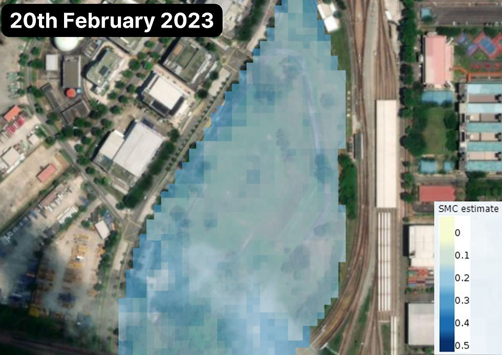
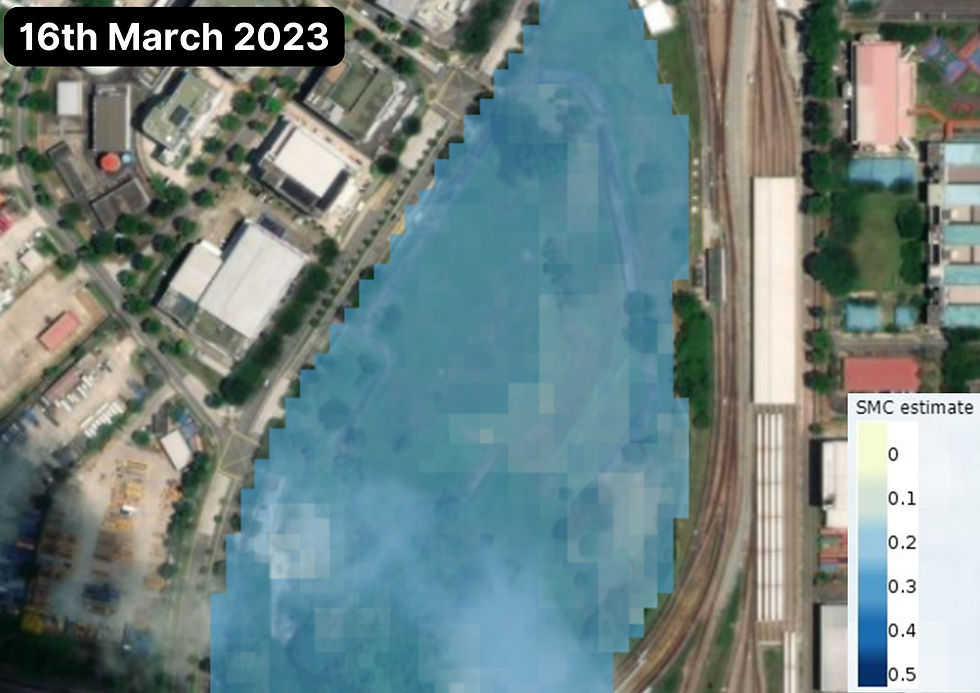
Satellite remote sensing, particularly using technologies like Synthetic Aperture Radar (SAR), provides a scalable, cost-effective alternative to monitor soil moisture content over large areas with high temporal resolution.
The Role of Soil Moisture Measurement in Infrastructure Management
Soil moisture variations significantly influence ground conditions, impacting the stability of railways, roads, tailings storage facilities, and other critical infrastructure. Excess moisture can weaken soil structures, leading to subsidence, landslides, or even catastrophic failures. Conversely, prolonged dry conditions may cause shrinkage and cracking, further compromising structural integrity.
Accurate, frequent, and wide-scale soil moisture measurement is therefore crucial for asset managers seeking to prevent costly maintenance issues and ensure long-term operational safety.
Satellite Remote Sensing for Soil Moisture Content Analysis
Satellite-based techniques offer a remote, non-intrusive approach to soil moisture monitoring. These methods include passive microwave sensors, active radar sensors, and satellite-mounted Synthetic Aperture Radar (SAR) technologies. Among these, SAR stands out for its ability to measure ground displacement with millimetre-level precision, along with soil moisture fluctuations.

By analysing phase changes in radar signals captured over time, Interferometric Synthetic Aperture Radar (InSAR) can detect subtle ground surface movements associated with moisture-induced swelling or subsidence.
Advantages of SAR for Soil Moisture Measurement
Wide Coverage & High Resolution: SAR allows for consistent monitoring of vast geographical areas, including remote or inaccessible locations where ground-based sensors are impractical.
Historical Data Analysis: With decades of archived satellite data, SAR enables long-term trend analysis of soil moisture variations, aiding predictive maintenance and risk assessment.
Frequent Monitoring: Many modern radar satellites, such as Sentinel-1, provide revisit intervals of just a few days, ensuring timely detection of soil moisture changes.
Integration with Geotechnical Knowledge: SAR-derived soil moisture measurement can be combined with geotechnical know-how to create comprehensive geohazard models and reports that add meaning to data.
Cost-Effectiveness: Compared to deploying and maintaining extensive ground sensor networks, satellite-based methods reduce operational costs while maintaining high reliability.
Aspect | Traditional In-Situ Methods | SAR Satellite Technology |
Methodology | Direct physical measurement using probes, sensors, or sampling | Indirect measurement via radar backscatter |
Spatial Coverage | Point-based measurements (typically 1-100 points per site) | Wide-area coverage (up to thousands of km2 per analysis) |
Spatial Resolution | High at sensor location, requires interpolation between points | Consistent 10-30m (standard) or 1-3m (high-resolution) across the entire area |
Temporal Coverage | Continuous data at installed locations | Periodic snapshots based on satellite revisit time (typically 6-12 days) |
Historical Analysis | Limited to period since sensor installation | Can analyse historical data back to 1990s using archived satellite imagery |
Weather Dependence | Most sensors function in all weather conditions | Functions in all weather conditions, day or night |
Deployment Effort | High: requires physical installation, maintenance, and site access | Low: no on-site equipment installation required |
Equipment Vulnerability | Subject to damage, theft, vandalism, or wildlife interference | Remote sensing with no on-site equipment |
Installation Time | Days to weeks for comprehensive network deployment | Immediate start using existing satellite data |
Maintenance Requirements | Regular calibration, battery replacement, data collection | No field maintenance required |
Site Access Requirements | Physical access needed for installation and maintenance | No site access required |
Initial Investment | $2,000 - $5,000 per sensor location + installation costs | $5,000 - $20,000 for initial analysis (area dependent) |
Ongoing Costs | Maintenance, replacement, data transmission, labour | Regular monitoring subscriptions or per-analysis costs |
Cost Scalability | Costs increase linearly with area coverage | Costs increase marginally with area coverage |
Break-Even Point | More economical for very small areas | More economical for areas >1km2 |
Measurement Precision | +/- 1-3% volumetric water content (direct measurement) | Indirect via displacement: +/- 1-2mm vertical movement |
Measurement Depth | Varies by method: 10cm to 2m depth | Surface movement only (inference of deeper conditions) |
Real-Time Capability | Real-time data possible with telemetry | Delay based on satellite revisit + processing time (typically 1-2 days) |
Best Applications | Critical point locations requiring continuous monitoring | Wide-area assessment, trend analysis, remote locations |
Complementary Use | Provides ground-truth calibration points | Extends point-based data across wider areas |
Note: Optimal monitoring strategies often combine both approaches, using SAR for wide-area screening and traditional sensors at critical locations identified through satellite analysis.
Applications of Soil Moisture Measurement in Infrastructure Asset Management
Railway and Road Networks
Excessive soil moisture content can lead to track deformation, embankment instability, and road subsidence. Moreover, areas of increased soil moisture may indicate poor drainage, seepage, or leaks. Continuous monitoring with SAR helps rail operators and highway authorities identify high-risk zones and schedule proactive maintenance, preventing costly service disruptions and structural failures.
Asset Type | Critical Soil Moisture Concerns | RecommendedMonitoring Approach | Key Parameters | Warning Signs |
Railway Embankments | Ballast contamination, subgrade softening, slope instability | SAR + ground piezometres, baseline: 12-day SAR, enhanced: 6-day SAR + weekly sensor readings | Vertical displacement rate, lateral movement, correlation with rainfall | Progressive settlement >3mm/month, seasonal movement exceeding historical patterns, localised displacement clusters |
Railway Cuttings | Slope destabilisation, clay shrink/swell, surface water ingress | SAR + inclinometres at critical slopes, optical satellite imagery (vegetation indicators) | Rotational movement, tension crack development, drainage efficiency | Movement acceleration after rainfall, step-change in displacement rate, progressive lateral displacement |
Highway Embankments | Settlement, fill material saturation, erosion and piping | Combined X-band and C-band SAR, ground penetrating radar at anomalies | Settlement rate, void development, moisture content in fall | Accelerating settlement, pavement cracking patterns, moisture-related surface patterns |
Bridge Approaches | Differential settlement, approach slab undermining, abutment movement | High resolution X-band SAR, corner reflectors, settlement plates | Differential movement, seasonal patterns, transition zone behaviour | Step-change in displacement, movement correlation with rainfall, progressive settlement >5mm/year |
Tunnels & Underground Structures | Settlement troughs, groundwater changes, portal stability | 3D SAR decomposition, piezometric array, satellite and ground combined | Surface expression of moisture changes, groundwater level variations, structural movement | Development settlement trough, asymmetric movement patterns, unexpected groundwater changes |

Tailings Storage Facilities
Tailings dams are highly sensitive to moisture changes, as excessive water content in tailings or seepage from the structure itself can compromise dam stability. SAR-based soil moisture measurement supports early warning systems, enabling tailings dam owners to take pre-emptive action before failures occur.
Asset Type | Critical Soil Moisture Concerns | RecommendedMonitoring Approach | Key Parameters | Warning Signs |
Tailings Storage Facilities | Dam body saturation, foundation seepage, phreatic surface elevation | Multi-satelliteSAR, piezometer network, integration with internal instrumentation | Deformation rate, moisture content changes, beach width variations | Localised bulging, progressive crest settlement, development of wet spots, anamolous seepage |
Open Pit Slopes | Pore pressure increase, slope destabilisation, bench failure progression | Corner reflector network, multi-band SAR, piezometer integration | Vector movement, acceleration trends, correlation with blasting/rainfall | Developing failure geometries, movement rate changes, new tension cracks development |
Waste Rock Dumps | Basal saturation, internal erosion, slope stability | L-band and C-band SAR, optical satellite for surface indicators, thermal imaging | Creep rate, surface water patterns, temperature anomalies | Accelerating movement, development of seepage points, progressive toe bulging |
Process Water Infrastructure | Embankment stability, seepage detection, foundation conditions | Regular SAR monitoring, thermal imaging, electromagnetic surveys | Structural integrity, containment effectiveness, foundation behaviour | Progressive deformation, temperature anomalies, development of wet areas |
Geotechnical Engineering and Slope Stability
Soil moisture fluctuations directly influence landslide susceptibility. By integrating SAR with geotechnical models, engineers can assess potential slope failures, design mitigation strategies, and ensure the safety of infrastructure projects built on unstable terrain.
Asset Type | Critical Soil Moisture Concerns | RecommendedMonitoring Approach | Key Parameters | Warning Signs |
Active Landslides | Groundwater fluctuations, slope saturation, drainage effectiveness | Multi-band SAR, corner reflectors network, integration with rain gauges | Movement rate, acceleration patterns, response to rainfall | Velocity increase after rainfall, development of new scarps, movement area expansion |
Unstable Slopes | Precursor movements, drainage conditions, erosion development | L-band and C-band SAR, optical satellite for surface changes | Creep behaviour, seasonal patterns, new tension features | New displacement patterns, accelerating movement, developing failure geometry |
Subsidence Zones | Groundwater withdrawal impacts, karst development, mining subsidence | Long-term SAR time series, integration with groundwater levels | Subsidence rate, spatial extent, correlation with extraction | Bowl development, linear features along faults, correlation with pumping |
Expansive Clay Areas | Seasonal heave/settlement, foundation impact, utility damage | Multi-temporal SAR, soil moisture correlation | Seasonal amplitude, shrink swell/cycles, spatial distribution | Increasing amplitude, infrastructure damage patterns, changes to historical patterns |
Permafrost Areas | Thaw subsidence, thermokarst development, infrastructure impacts | L-band SAR, thermal satellite imagery, long-term monitoring | Thaw settlement, seasonal effects, thermal regime | Progressive subsidence, new thermokarst features, infrastructure damage correlation |
Note: These matrixes provides general guidelines. Specific monitoring programs should be developed based on site conditions, risk profile, infrastructure criticality, and available resources. Integrated monitoring approaches combining satellite and ground-based methods typically provide the most comprehensive risk management strategy.
The Future of Soil Moisture Monitoring
As satellite technology advances, the precision and reliability of soil moisture measurement will continue to improve. Emerging constellations of high-resolution radar or SAR satellites, AI-driven data analytics, and cloud-based geospatial platforms will further enhance the ability to detect, analyse, and respond to soil moisture dynamics in near real-time.
For infrastructure asset managers, adopting satellite-based soil moisture monitoring is no longer a luxury - it is a necessity for sustainable and resilient infrastructure management. By leveraging SAR and other remote sensing techniques, organisations can enhance decision-making, reduce maintenance costs, and improve the safety and longevity of critical infrastructure assets.
Unlock the power of satellite remote sensing for soil moisture measurement - contact Geofem today to learn how we can support your infrastructure monitoring needs.
Kommentare